
El Niño Could Ignite a Fierce 2026 Eastern Pacific Hurricane Season, Raising Risks for the U.S. West
Forecasters warn the 2026 Eastern Pacific hurricane season may be exceptionally active due to an expected El Niño, raising risks of more storms, stronger hurricanes, and rapid intensification that could affect coastal regions and inland areas like California.
- Elevated Eastern Pacific activity: El Niño-driven warmer seas and reduced local wind shear could produce more storms and faster rapid intensification events (Fox Weather: https://www.foxweather.com/weather-news/el-nino-boost-hurricane-activity-eastern-pacific-2026).
- Model odds favor El Niño: NOAA and several models show ~61% chance of El Niño by July and ~25% chance of a super El Niño by fall (Time: https://time.com/article/2026/04/10/super-el-nino-2026-what-to-know/; Weather Underground: https://wu-next-prod-us-west-2-aws.wunderground.com/article/news/climate/news/2026-04-08-super-el-nino-forecast-2026-hurricane-season-summer-winter).
- Local impacts matter: Mexico’s forecast calls for 18–21 named storms, 9–11 hurricanes and 4–5 major hurricanes in the Eastern Pacific (see Mexico’s weather service (SMN): https://en.wikipedia.org/wiki/2026_Pacific_hurricane_season).
How El Niño fuels Eastern Pacific storms
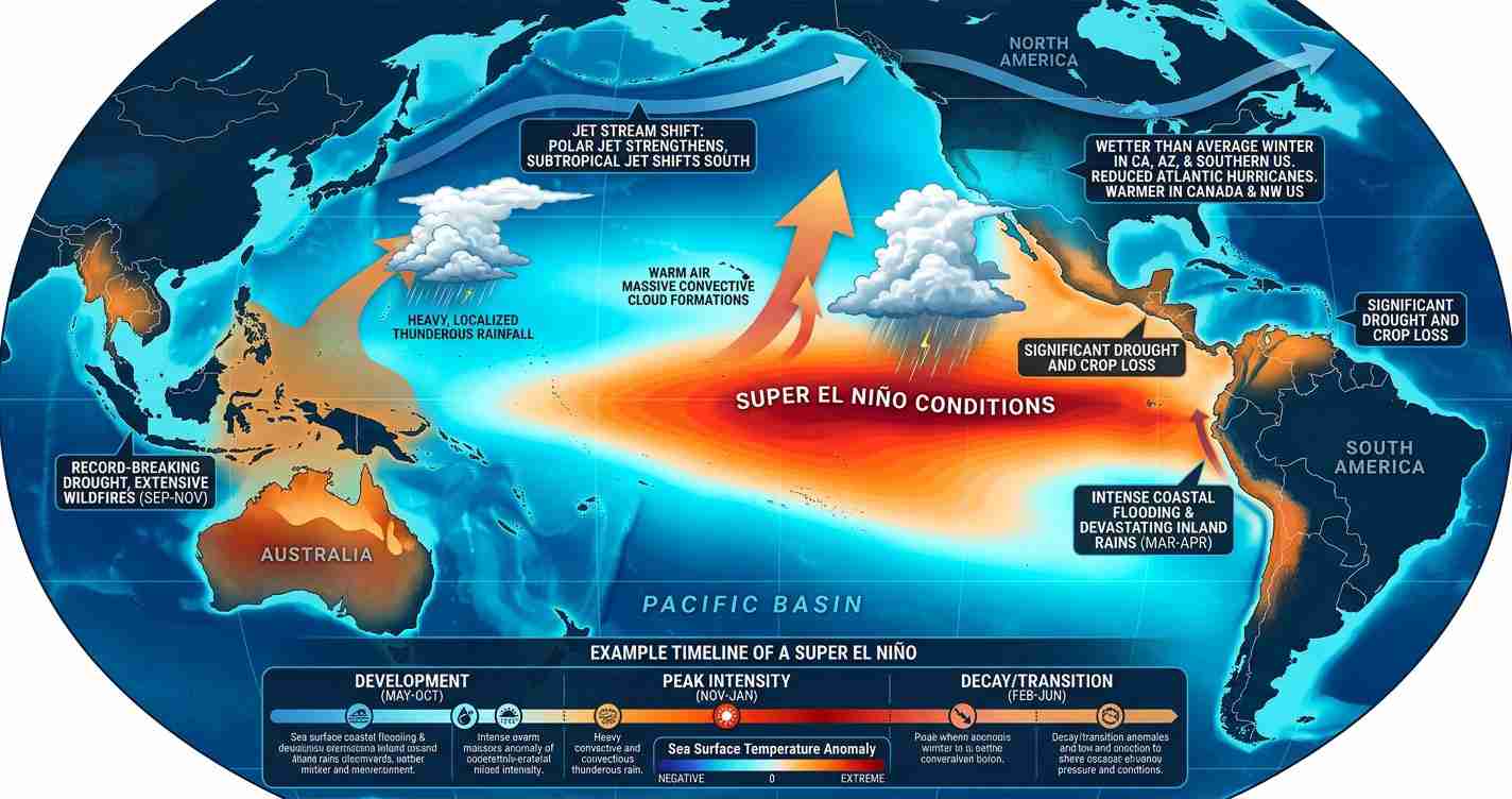
El Niño is a periodic warming of broad areas of the central and eastern equatorial Pacific. Warmer sea surface temperatures supply more energy to developing tropical systems, helping them organize and strengthen. At the same time, El Niño alters upper-level wind patterns: it tends to increase wind shear over the tropical Atlantic and Gulf of Mexico — which suppresses Atlantic development — while reducing local shear over parts of the Eastern Pacific, favoring storm formation and intensification. This contrast explains why El Niño often brings a quieter Atlantic season but a more active Eastern Pacific (Fox Weather: https://www.foxweather.com/weather-news/el-nino-boost-hurricane-activity-eastern-pacific-2026).
Warm seas and deep heat: fuel for rapid intensification
Not just surface warmth matters — the ocean heat content beneath the surface is critical. In parts of the Eastern Pacific, sea surface temperatures (SSTs) are currently 1–3°C above average, and the warm layers extend deeply. When a tropical storm traverses deep warm water, it can tap substantial energy and intensify rapidly.
Case in point: Hurricane Otis (2023) dropped ~73 millibars and increased winds ~115 mph within 24 hours, a stark example of dangerous rapid intensification driven by deep heat.
Forecasters note that present high ocean heat content raises concerns about similar sudden intensification in 2026 (Fox Weather: https://www.foxweather.com/weather-news/el-nino-boost-hurricane-activity-eastern-pacific-2026).
Forecasts and model outlooks for 2026
NOAA and multiple climate centers currently favor El Niño developing in late spring to summer 2026, with models indicating roughly a 61% chance by July and a ~25% probability of a super El Niño by fall. A stronger event would push warming farther across the central and eastern Pacific and could further amplify Eastern Pacific hurricane activity (Time: https://time.com/article/2026/04/10/super-el-nino-2026-what-to-know/; Weather Underground: https://wu-next-prod-us-west-2-aws.wunderground.com/article/news/climate/news/2026-04-08-super-el-nino-forecast-2026-hurricane-season-summer-winter).
Mexico’s meteorological service (SMN) has already issued a busy-season projection: 18–21 named storms, 9–11 hurricanes, and 4–5 major hurricanes in the Eastern Pacific (Wikipedia: https://en.wikipedia.org/wiki/2026_Pacific_hurricane_season). Historical records since 1990 show moderate or stronger El Niño years produced above-average Eastern Pacific activity ~85% of the time.
Timing matters: early versus late El Niño onset
When El Niño strengthens matters for seasonal impacts. If it develops before mid-summer, favorable conditions can persist across the July–October peak, potentially producing more early-season storms. If El Niño arrives later, the Atlantic and Gulf might see more activity earlier, shifting heightened risk to the Eastern Pacific later in the season.
Forecasters also watch the Madden–Julian Oscillation (MJO), a tropical pulse that can temporarily enhance convection and storm development as it moves through the Pacific; the MJO plus early El Niño signals could mean an earlier and stronger Eastern Pacific peak (YouTube discussion of tropical patterns and MJO: https://www.youtube.com/watch?v=JlHLQ_4U3t8).
Season dates and what to expect
Eastern Pacific season: May 15–November 30, 2026. Central Pacific: June 1–November 30. Peak activity typically occurs July–October. With current conditions and model guidance, forecasters expect more named storms than recent quiet years, with early formation possible around mid‑June and sustained activity through fall depending on El Niño’s strength (Fox Weather: https://www.foxweather.com/weather-news/el-nino-boost-hurricane-activity-eastern-pacific-2026; Wikipedia: https://en.wikipedia.org/wiki/2026_Pacific_hurricane_season).
What communities, mariners and emergency planners should watch
- Rapid intensification risk: Coastal communities, mariners, and Pacific territories should prepare for storms that can strengthen quickly — increasing the urgency for early warnings and rapid evacuations (Fox Weather: https://www.foxweather.com/weather-news/el-nino-boost-hurricane-activity-eastern-pacific-2026).
- Track uncertainty: Many storms remain offshore, but faster-developing systems raise risks for coastal flooding, storm surge, and disruptive waves affecting ports and marinas.
- Seasonal preparedness: Review evacuation routes, shelters, communication plans, and contingency business plans for shipping, fishing, and tourism (Time: https://time.com/article/2026/04/10/super-el-nino-2026-what-to-know/).
Implications for Fresno, California
Economic impact
Though inland, Fresno can still be affected by heavy rains from Pacific storms or their remnants. Flooding can damage crops, disrupt trucking routes, and slow harvests — with direct costs to irrigation, labor, and transport. Central Valley agriculture is particularly sensitive to sudden, late-season storms.
Political consequences
County and city leaders may face questions on preparedness, spending, and communication. Fresno County may need tighter coordination with state agencies if systems bring heavy rain or strong winds. Resource allocation (sandbags, shelters, road crews) could come under scrutiny during active periods.
Social effects
Flooding and sudden storms can disproportionately affect low-income neighborhoods and farmworker communities. Power outages, closed roads, and school interruptions can disrupt daily life and livelihoods. Clear public messaging — including outreach to non‑English speakers — is essential to reduce harm.
Cultural relevance
Outdoor festivals, fairs, and agricultural calendars may face cancellations or schedule changes. For many residents and seasonal workers, storm timing can affect traditions and income tied to harvest cycles.
Practical applications for residents
- Stay informed: Monitor local National Weather Service briefings and state emergency alerts during summer and fall.
- Prepare for rain and floods: Have cleanup supplies, a basic go-bag, and a family communication plan ready.
- Protect crops and property: Farmers should consult extension services and plan for sudden heavy rains that can saturate fields.
- Plan for outages: Ensure backup power plans for refrigeration, pumps, and critical equipment.
Sources and further reading
- Fox Weather: El Niño boost to Eastern Pacific hurricane activity, 2026 — https://www.foxweather.com/weather-news/el-nino-boost-hurricane-activity-eastern-pacific-2026
- Wikipedia: 2026 Pacific hurricane season — https://en.wikipedia.org/wiki/2026_Pacific_hurricane_season
- Time: What to know about a potential super El Niño in 2026 — https://time.com/article/2026/04/10/super-el-nino-2026-what-to-know/
- Weather Underground: Super El Niño forecast, 2026 — https://wu-next-prod-us-west-2-aws.wunderground.com/article/news/climate/news/2026-04-08-super-el-nino-forecast-2026-hurricane-season-summer-winter
- YouTube explainer on El Niño impacts — https://www.youtube.com/watch?v=osW5wCPwSJM
- YouTube discussion of tropical patterns and MJO — https://www.youtube.com/watch?v=JlHLQ_4U3t8
