Reagan-era megaberg A-23A nears final breakup after decades at sea, leaving a wake of blue meltwater
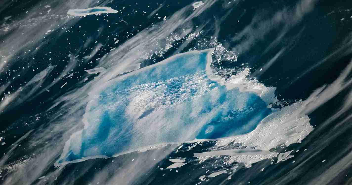
Iceberg A-23A, a Reagan-era megaberg that calved from the Filchner–Ronne Ice Shelf in 1986, is now rapidly fragmenting in warmer South Atlantic waters, shrinking to about 1,182 km² and covered in bright blue meltwater ponds.
- Decades-long story: A-23A calved in 1986 and remained grounded in the Weddell Sea for more than 30 years before drifting northward.
- Rapid 2024–2025 breakup: Major calvings and edge collapse reduced the berg from roughly 4,000 km² at calving to an estimated 1,182 km² by January 2026.
- Blue meltwater ponds: Extensive surface pools absorb red light, reflect blue, and can force fractures that speed disintegration.
- Tracked by satellites and ships: Agencies including NASA Earth Observatory — Meltwater Turns Iceberg A-23A Blue, JAXA Earthview, and the British Antarctic Survey continue monitoring.
Background and origin
A-23A broke free in 1986 from the Filchner–Ronne Ice Shelf in the Weddell Sea. At calving it measured about 4,000 km² (~1,540 mi²), nearly twice the size of Rhode Island, and for more than three decades it remained grounded in shallow Weddell Sea waters. During that time new snow and basal melting altered its surface but the berg changed little in overall position. Sources include NASA, the British Antarctic Survey, and JAXA.
Drift, grounding and the Taylor column
Around 2020 A-23A finally lifted off the seabed and began a slow drift. Satellite tracking by agencies including JAXA, EUMETSAT and NOAA/NESDIS documented its movement into the Antarctic Circumpolar Current.
At times the berg became quasi-stationary when a Taylor column formed over an undersea bank (notably Pirie Bank), trapping the berg and delaying its northward drift. Later A-23A moved toward South Georgia and briefly entered shallower continental-shelf waters, where grounding would have raised ecological risks for local feeding routes.
Recent breakup and current status
Satellite records show A-23A began fragmenting more rapidly as it moved north into warmer open ocean waters in 2024–2025. Edge collapse and several significant calving events during July–September 2025 removed large pieces from the tabular berg. By February 2025 JAXA data showed major area loss, and analyses by September 2025 placed the berg at less than half its original area. The U.S. National Ice Center estimated an area of 1,182 km² (456 mi²) in early January 2026 (NOAA/NESDIS).
Why the blue meltwater matters
High-resolution imagery from NASA‘s MODIS sensors and photographs from the International Space Station reveal extensive bright blue meltwater ponds on A-23A’s surface. These pools form when meltwater fills cracks and shallow depressions and sits on top of the ice, absorbing red wavelengths and appearing vividly blue in satellite images.
“Surface meltwater can drive fractures deeper into ice shelves and bergs. When ponds collect in surface cracks, the pressure of water forces the cracks to open.” — Ted Scambos (glaciologist)
The risk: ponding increases the likelihood of sudden calving and rapid disintegration by forcing cracks wider and weakening ice from above (NASA).
Observations and methods
Scientists use a suite of tools to follow A-23A: optical and radar satellites from NASA, JAXA, EUMETSAT and others provide repeated images and radar. Ship-based sampling — for example by the UK polar research vessel RRS Sir David Attenborough in December 2023 — complements remote sensing with water-property and bathymetry data (BAS).
Ecological and oceanographic effects
As A-23A melts it releases fresh water and mineral dust trapped in the ice. That dust can fertilize surface waters and potentially stimulate short-term phytoplankton blooms. However, grounding near islands such as South Georgia could physically block access to feeding grounds and harm seals and penguins that rely on open routes during breeding.
Researchers have sampled surrounding waters to detect chemical and biological shifts tied to melting and to monitor how meltwater input modifies local circulation and productivity (British Antarctic Survey).
Long-term significance and climate context
A-23A is notable for the rarity of being tracked for roughly four decades, from calving to near-disintegration. Its long life offers scientists a unique opportunity to study how so-called megabergs evolve, interact with ocean currents and topography, and respond when they reach warmer waters. Although A-23A calved long before the most rapid recent Antarctic changes, its accelerated breakup in 2024–2025 underscores how persistent ice masses can disintegrate quickly under warmer ocean and air conditions (NASA; JAXA).
What scientists are watching next
Teams will keep tracking remaining fragments via satellites and ships until pieces become too small to follow routinely. They expect continued calving, shrinking area, and more surface ponding. Monitoring focuses on meltwater distribution, water chemistry and the timing of breakup events to refine models that predict how other large ice masses might behave (NASA; JAXA).
Implications for Fresno, California
Why should Fresno readers care? The physical processes on display — large ice melting, freshwater input to the ocean, and shifts in ocean circulation — feed into global climate patterns that influence weather far from Antarctica. Changes in polar melt and ocean heat distribution can affect atmospheric rivers, the jet stream, Sierra Nevada snowpack and seasonal rains, all of which matter to Fresno’s water supply and agriculture (NASA).
Local planning: City and county planners, emergency managers and water districts should continue to use climate assessments that account for polar-driven shifts in precipitation patterns when planning reservoirs, groundwater recharge and agricultural water allocations (NOAA/NESDIS).
Education: The A-23A event is a teachable moment for schools and community groups. Local universities and extension services can use satellite images and simple models to show how polar processes connect to valley weather and water planning (JAXA; NASA).
Reporting and sources
This article draws on satellite observations and analyses from major agencies and published summaries. Key references:
- NASA Earth Observatory — Meltwater Turns Iceberg A-23A Blue
- JAXA Earthview
- British Antarctic Survey — A23A breaks free
- NOAA/NESDIS — Tracking A23A
- EUMETSAT case study — Iceberg A23 through the decades
- Wikipedia — A23a (compiled timeline and references)
Further monitoring by these agencies will clarify how quickly the remaining mass disappears and what local and global ocean changes follow as the Reagan-era megaberg finishes its long journey across Antarctic and sub-Antarctic waters.